Contrary to frequent
rumors, ongoing
survey efforts at
Lake Lanier are not
being performed to move present
property Iines.The Government line is currently
monumented in its permanent location, except in
isolated cases where land exchanges, acquisitions or
disposals would alter the property line location.
Permanent survey markers are located at all property
comers except where they have been accidently
destroyed by construction or by vandalism. The
maintenance survey effort that is observed around
the lake involves replacing missing property corners,
repainting line witness trees, and setting
intermittent "Point On Line" monuments between
property corners. The "Point On Line" monuments
will aid both reservoir personnel and adjacent
property owners in locating the property line on long
tangents where neither property corner marking the
end of the tangent can be easily viewed. A source of
misunderstanding concerning the Government
property line occurs when one assumes that the
painted line witness trees are the exact
property
line. These trees are painted to alert the observer
that a property line is nearby. Also, signs are placed
on some of these painted trees stating "United States
Army Engineer District, Mobile - Boundary Line
Nearby" or "United States Army Engineer District,
Mobile - Easement Line". If activities require knowing
exactly where the line is, a private registered land
surveyor should be contacted. Since these painted
trees are not on the exact property line, repainting
may give the appearance to an adjacent property
owner that the line has been "moved" when, in fact, it
may only indicate that a
different tree was painted.
If you have
questions about the location
of the boundary line, contact
the Lake Lanier Operation Management Office:
(770) 945-9531. A field appointment with a Corps
ranger can be scheduled to answer any questions
you may have concerning public property and our
Lakeshore Use Permit Program.
U.S. Army Corps of Engineers Lake
Sidney Lanier
P O. Box 567 Buford,
GA 30518
US Army Corps
of Engineers
Mobile District
BOUNDARY LINE MARKINGS
AND PERMITTED USES
OF PUBLIC LAND
AT LAKE LANIER
MISCONCEPTIONS
QUESTIONS
INTRODUCTION
Annually, Lake Sidney Lanier provides a
source of recreation for more than 19 million visitor
days of use. The popularity of Lake Lanier's 38,000
acres of water and over 19,000 acres of land (at 1070
mean sea level) has made it the most highly visited
Corps of Engineers lake in the nation. Resource
protection and management is necessary to preserve
the project for future generations while providing
quality recreation opportunities for today's visitors.
Management must insure a balance between the
recreation user, the environment, and conservation of
project resources. Consideration must also be given
to conflicting uses between the general public and
the owners of adjacent private property.
PERMITTED PRIVATE USE
The Lakeshore Management Plan furnishes
guidance for the protection and preservation of
environmental characteristics of Lake Lanier's
shoreline. Copies of the plan are available at the
Operation Management Office. Public land adjacent
to the lake is delineated into different areas of use.
This designation of public land allows the District
Engineer to approve specific types of private use in
certain areas around the lake. Private use is
regulated through a Lakeshore Use Permit program
that may allow individuals with approved access to
public land to construct and/or install specific
facilities, such as a boat dock, or water and electric
lines. Although private facilities may be authorized,
the ownership of adjacent private land does not
convey any exclusive rights to public land. The
placing of structures or special use of public land
without prior written authorization or deviation from
the terms of the authorization may constitute a
violation of Title 36, Part 327, United States Code of
Federal Regulations.
Without proper authorization, the
construction, placement, or continued existence of
any structure or item of any kind under, upon, in, or
over the project lands or waters and/or the
destruction, injury, defacement, removal, or any
alteration of public property including natural
formations, historical and archeological features,
and vegetation growth is unlawful.
The Corps of Engineers requests the
assistance of all citizens in preventing
encroachments on public or private land around
Lake Lanier. To assist in identifying public property
at Lanier, an extensive boundary maintenance
program exists that includes the brushing out and
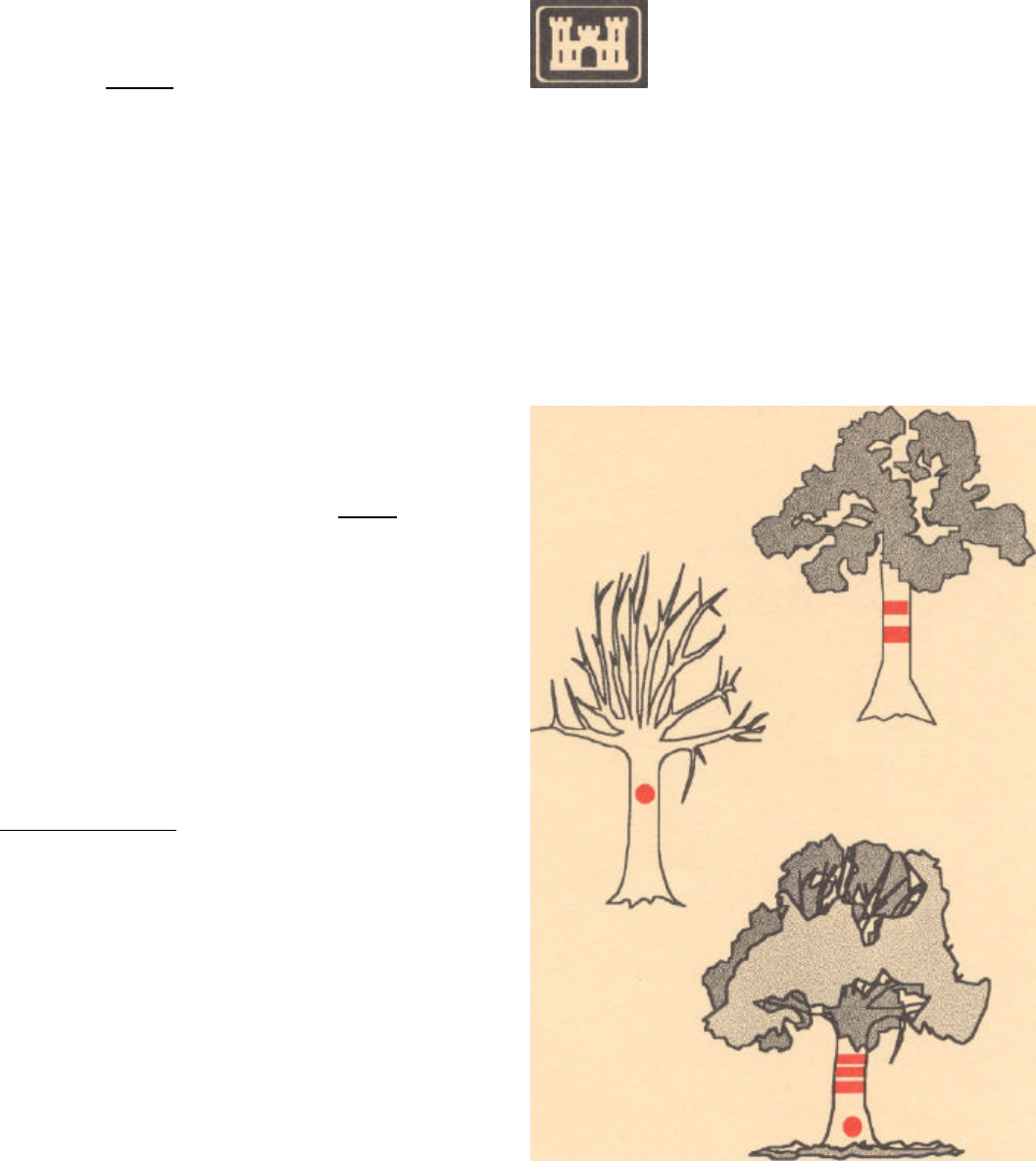
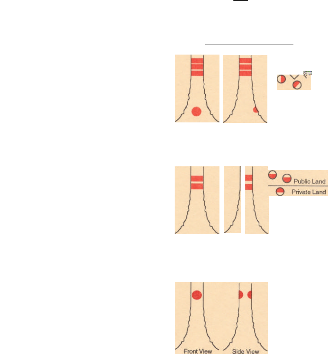
"Painting the boundary line" actually means
painting witness trees near the line. At Lake Lanier, red
paint is used to mark witness trees along the fee
boundary. White paint is used to identify the limits of
Government owned easements. Drawings 1 through 3
illustrate the different types of markings and describes
their meanings.
CORNER WITNESS TREE
2
3
Front View Side View
Front View
Side View
LINE WITNESS
TREE
CENTER LINE
TREE
Tree is painted with
three horizontal
lines that encircle
the trunk. The circle
painted below the
lines faces the
property corner.
The most common
witness tree. Two
horizontal lines
face the boundary
line.
Public Land
Private Land
This witness is
used when the
line goes through
the tree. A circle
is painted on
both sides of the
trunk.
